Introduction
Physical Features
Flora
Fauna
Human History
Human Benefits
Environmental Issues
![]() he sculpting of the region's topography
dates back about a million years to the beginning of the Pleistocene Ice
Age, when glaciers hundreds of feet thick covered much of the North American
continent. The massive ice cap claimed moisture from the atmosphere and
the oceans, exposing sea bottoms by lowering sea levels as much as 450
feet.
he sculpting of the region's topography
dates back about a million years to the beginning of the Pleistocene Ice
Age, when glaciers hundreds of feet thick covered much of the North American
continent. The massive ice cap claimed moisture from the atmosphere and
the oceans, exposing sea bottoms by lowering sea levels as much as 450
feet.
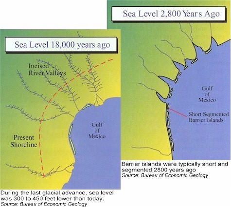
After several major and minor thaws, (the last taking place about 18,000 years ago), raging rivers cut deep canyons through the sands and clays of the continental shelf.
As a few thousand years passed, the rising seawater filled the river canyons. Eroded by abundant rainfall, sand, silt, and clay from the hills filled in the submerged canyons, and formed wide floodplains along the river valleys.
Sea level height stabilized about 2,800 years ago. River valleys continued to fill with sediment creating deltas, bays, and creeks in the process.
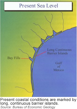
During the last 2,800 years, barrier islands were formed from sand carried by rivers and wind-driven currents. Today, the slowly rising sea level continues to drive the landward migration of these islands.
Barrier islands serve as the first line of defense against storm surges, relentless wind, and crashing waves brought by natural occurrences such as tropical storms and hurricanes. Combined, Padre Island and adjoining Mustang Island stretch about 130 miles. Padre Island is the longest barrier island in the world. Once called Isla Blanca, it is famed for its white sand and whitecapped waves.
The Coastal Bend encompasses a region of diverse habitats - from mesquite brush country to coastal sand dunes, pancake-flat prairies to rising bluffs, drought-parched lands to submerged wetlands.
The sub-tropical humid Coastal Bend stretches along the Gulf of Mexico, rising gently from sea level to an elevation of 200 feet or more at points furthest from the coastline. The area is part of the Coastal Plain Geological Province, a belt of varying widths that begins in New Jersey on the Atlantic Coast, circles the perimeter of the Gulf of Mexico, and ends in the Yucatan.
Fresh Water - Life support of the estuary
The Nueces and Frio rivers, primary freshwater sources for the Corpus Christi Bay system, emerge as intermittent streams from limestone canyons of the Edwards Plateau. These rivers snake above and below ground, winding through the northern part of South Texas. Sporadic episodes of rain occasionally raise the rivers and streams out of their banks. Downstream, the rainwater flows into the salty waters of the bay bringing new life and nutrients to the estuaries.
In proportion to the volume of its receiving basin, the bay system has very limited freshwater inflow. Between 1968 and 1987, freshwater inflow declined significantly because of controlled reservoir releases and sparse rainfall in the watershed.
The Coastal Bend boasts a combination of aquatic habitats found nowhere else. Corpus Christi Bay serves as the ecozone or boundary between two distinct estuarine ecosystems. Copano and Mesquite Bays, to the north, are low-salinity bays, attracting majestic whooping cranes. The rare, hypersaline Laguna Madre and Baffin Bay in the southern drainage basin are high-salinity bays, supporting expansive meadows of seagrasses.
The Bay System is vast, comprised of 533,100 acres of open water and 147,293 acres of salt marsh wetlands and seagrass beds. These important habitats provide shelter and protection to juvenile fish, shrimp, and blue crabs. These habitats also serve as vital spawning grounds for 95 percent of the commercial and recreational fish species caught in the Gulf of Mexico.
Although rainfall averages an annual 27 to 36 inches, the region’s evaporation rate is a depleting 60 inches per year. From 1931 to 1985, 96 out of 216 seasons had less than normal rainfall and 28 of those 96 represented severe drought potential.